Entry Points:

About Island in the Sky
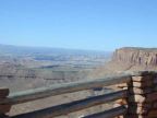
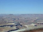
The Island in the Sky is a mesa bounded on all sides by high cliffs that drop into the canyons of the Green River to the west and the Colorado on the east. On the northern tip it is attached by a narrow neck of land between cliffs on either side to another mesa. At the base of the cliffs lies another plateau, called the White Rim, because of the unusually light color of the ground at that level. (See this in the Green River Overlook above.) This plateau extends outward for some distance until it ends abruptly at the edge of a yet deeper chasm. The rivers lie at the bottom, mostly hidden from sight.
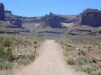
The Shafer Trail Road makes the descent from the Neck, by many switchbacks, to the White Rim, and the White Rim Road circles from there all the way to the other side of the Island in the Sky. Another road, Potash Road, leaves the park to the east and comes to Moab. Take a good look at the pictures of these roads and see if you have the heart and the vehicle to navigate them! A paved road enters the Island in the Sky district from the north.
Street Index
|
Grand View Point Road Green River Overlook Road Potash Road |
Shafer Trail Road Upheaval Dome Road White Rim Road |